Anticline


Anticlines are folded rock formations that have an upwards convex shape.[3] This means that anticlines look like a lowercase “n” or an uppercase “A” (“A is for Anticline” is a common phrase for remembering the shape of anticline). They form from layers of rock that were originally horizontal and relatively flat. Pressure was exerted on two, opposing sides of the rock layers, causing them to wrinkle and squish together. The layers rumple into a shape resembling a wavy line (or a series of sideways “S” shapes). The “n” shaped parts of the formation, or the parts that open down, are the anticlines and the “u” parts (the part that opens up) are the syncline. The pressures that cause this deformation can be small (e.g. local faulting) to large scale (e.g. tectonic plate movement) in nature. [3]
Anticlines can exist as a single fold or as a series of adjacent folds of alternating synclines and anticlines. The 'limbs' of these folds can have slopes that are very steep (even vertical) or quite shallow, only a few degrees. Since the rock layers of the anticline were originally flat when they were formed, and the sides of the anticline folded down when the layers deformed, the oldest rock is at the core or centre of the anticline. [3]
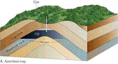
The core and inner layers of an anticline can act as reservoirs for various fluids. Anticline formations can be highly indicative of petroleum reservoirs in particular. This is especially true when the anticline is formed from sedimentary rock layers. Anticlines form a structural trap that can capture pockets of hydrocarbons in the bend of the arch. [4] Impermeable rock beds, often referred to as seals or cap rock, trap hydrocarbons in the anticline peak. This causes oil and natural gas to build up in the pore spaces of the reservoir rock at the core of the arch. The lowest parts of the reservoir rock are often filled with salty water, effectively sealing the hydrocarbons into the arch.[4] Generally speaking, the largest oilfields occur in anticlines containing sedimentary rock.[3]
For Further Reading
- Gas
- Hydrocarbon
- Oil and gas traps
- Oil
- Cap rock
- Reservoir
- Or explore a random page
References
- ↑ Wikimedia Commons. (September 17, 2015). NJ Route 23 Anticline [Online]. Available: https://upload.wikimedia.org/wikipedia/commons/4/48/NJ_Route_23_anticline.jpg
- ↑ Wikimedia Commons. (September 22, 2018). PETROLEUM TRAPS [Online]. Available: http://4.bp.blogspot.com/__nRwW6ejU8U/Syl6T-3hEVI/AAAAAAAACL8/edTYPl7fX7E/s400/anti.jpg
- ↑ 3.0 3.1 3.2 3.3 Aminzadeh and Dasgupta. (September 23, 2018). Chapter 2 - Fundamentals of Petroleum Geology [Online]. Available: https://doi.org/10.1016/B978-0-444-50662-7.00002-0
- ↑ 4.0 4.1 Petroleum Education. (September 19, 2015). Structural traps [Online]. Available: https://www.priweb.org/ed/pgws/systems/traps/structural/structural.html