Pacific Decadal Oscillation
Pacific Decadal Oscillation (PDO) is a long term ocean fluctuation of the Pacific Ocean causing sea surface temperatures to cool or warm over extended periods of time. The PDO fluctuates in its phases approximately every 20 to 30 years.[1] PDO broadens to cover the whole Pacific Basin which known as the InterDecadal Pacific Oscillation (IPO). The PDO is a natural form of climate variability, explaining short and long phases in climate caused by natural, large scale features. Other modes of climate variability include the Atlantic Multidecadal Oscillation, Northern Annular Mode, North Atlantic Oscillation, and more.
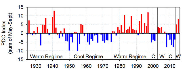
The PDO is frequently described as an extended El Niño like pattern of Pacific climate.[2] Pacific Ocean has a large impact on global weather climate. Research has shown when PDO is in a warm phase, global temperatures tend to increase and global temperatures tend to cool down when in a cool phase.[1] In the cool phase, cool waters wrap in a horseshoe shape around a core of warmer than average water. In the warm phase, this process is reversed.[1] Over the last hundred years, we have had only a handful of phase shifts:[1]
-
- 1905 - PDO switched to warm phase
- 1946 - PDO switched to cool phase
- 1977 - PDO switched to warm phase
- 2008 - PDO switched to cool phase

When sea surface temperatures are unusually cool in the interior North Pacific, warm along the Pacific Coast, and sea level pressures are below average over the North Pacific, the PDO has a positive value.[2] When the climate anomaly patterns are reversed, with warm sea surface temperature anomalies in the interior and cool sea surface temperature anomalies along the North American coast, or above average sea level pressures over the North Pacific, the PDO has a negative value.[2] The PDO is highly correlated with sea surface temperature in the northern California Current (CC) area.[4] These phases result from the direction of winter winds in the North Pacific: winter winds blowing primarily from the southwest result in warmer conditions in the northern CC.[4] The CC warms at such times due to onshore transport of warm waters that normally lie offshore. Conversely, when winds blow primarily from the north, upwelling occurs both in the open ocean and at the coast, leading to cooler conditions in the northern CC.[4]
How PDO Impacts Climate
The change in location of the cold and warm water masses alters the path of the jet stream. The jet stream in the northern hemisphere delivers storms across the United States. The PDO phase that we appear to have entered will act to steer the jet stream further north over the Western Canada and The United States.[5]
References
- ↑ 1.0 1.1 1.2 1.3 ”Pacific Decadal Oscillation (PDO)", Sealevel.jpl.nasa.gov. [Online]. Available: http://sealevel.jpl.nasa.gov/science/elninopdo/pdo/. [Accessed: 19- May- 2016].
- ↑ 2.0 2.1 2.2 "Pacific Decadal Oscillation (PDO) | Teleconnections | National Centers for Environmental Information (NCEI)", Ncdc.noaa.gov, 2016. [Online]. Available: https://www.ncdc.noaa.gov/teleconnections/pdo/. [Accessed: 19- May- 2016].
- ↑ National Oceanic and Atmospheric Administration. (July 22, 2016). ‘’PDO Modes’’ [Online]. Available: https://www.nwfsc.noaa.gov/research/divisions/fe/estuarine/oeip/figures/Figure_PDO-01.JPG
- ↑ 4.0 4.1 4.2 "Pacific Decadal Oscillation (PDO)", NOAA. [Online]. Available: https://www.nwfsc.noaa.gov/research/divisions/fe/estuarine/oeip/ca-pdo.cfm. [Accessed: 20- May- 2016].
- ↑ "Pacific Decadal Oscillation (PDO): Definition and Indices | NCAR - Climate Data Guide", Climatedataguide.ucar.edu. [Online]. Available: https://climatedataguide.ucar.edu/climate-data/pacific-decadal-oscillation-pdo-definition-and-indices. [Accessed: 23- May- 2016].

