Wind resource measurement
Wind resource measurement is an import aspect of wind power development. Information about how hard the wind blows and in what directions determines how much power a proposed wind farm in an area would produce (see wind power). A variety of technologies are available to measure wind conditions. The two most important characteristics of wind are speed and direction.[1] Several of the most common systems for collecting wind resource information are listed below.
Anemometers and Wind Vanes

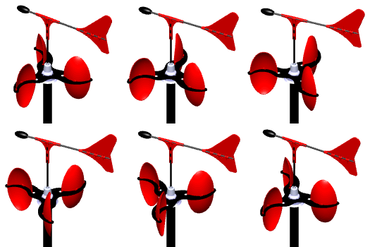
Anemometers are conventionally used for wind speed measurement.[3] The design is fairly simple: several cups are attached to spokes perpendicular to a central rotating shaft. The wind fills the cups and turns the central shaft. The wind speed is calculated based on the rotation speed of the central shaft.[4]
Correspondingly, wind vanes measure wind direction. The wind vane is mounted on a central rotation shaft which allows the vane to move freely.[5] The surface area of the vane is unevenly distributed on either side of the shaft. The side with the larger surface area will be pushed further by the wind and therefore, the smaller surface area will point in the direction the wind is blowing from.[6]
Meteorological Towers and Buoys

Meteorological (Met) towers are commonly used to measure wind speed and direction both on land and over water. The towers are generally between 50 m and 120 m high and are fitted with a variety of instruments, including anemometers and weather vanes, to measure the wind speed and direction.[8] Met towers are expensive to construct and operate: approximately $50 000/year for an on-land tower and several million dollars to construct towers offshore.[8] Towers are primarily used to determine the wind resource in an area as a precursor to constructing a wind power farm. Met towers collect very accurate information on wind direction, speed and turbulence.[8] They can also be outfitted with additional instruments to measure other local conditions such as temperature, pressure and water currents.[9]
Meteorological buoys are an alternative to met towers in water. Buoys are outfitted with the same kinds of instruments as met towers. However, buoys do not have the same height as towers nor do they provide the same depth of information; generally they are less than 12 m tall which means the data is limited to measuring surface conditions.[10] Remember, industrial wind turbines are often 100 m tall. In many cases this means a model is necessary to determine the likely wind speed and direction at the desired height, given the measured values at the height of the buoy.[11]
Remote Sensing
Remote sensing is a relatively new technology for measuring the wind speed. Wind speed can be measured remotely using instruments on the ground and mounted on airplanes or satellites. Sensors on the ground or on airplanes use Light Detection and Ranging (LiDAR) technology to measure the wind speed and direction.[11] LiDAR systems send out a signal which bounces off of particles carried by the wind and returns to the sensor.[11] Water droplets, dust and pollen are all examples of the kinds of particles that the sensor can detect.[12] The system measures the properties of the return signal to calculate the wind speed and direction.[11] These sensors are potentially able take the place of met towers with individual instruments such as anemometers and weather vanes.
Satellite technologies are still in development. Current approaches involve determining the wind speed over water by measuring the size and direction of waves. Surface waves are caused by wind and therefore can be used to determine wind speed and direction.[13]
References
- ↑ Windpower Engineering (2011). How is wind measured for wind turbines? [Online]. Available: http://www.windpowerengineering.com/design/test-measurement/how-is-wind-measured/
- ↑ Wikimedia Commons [Online], Available: https://commons.wikimedia.org/wiki/File:Elliptic-Anemometer-2-Direction-Vane-Animation-175x175px.gif
- ↑ B.M. Williams,"New Applications of Remote Sensing Technology for Offshore Wind Power," 2013. [Online] Available: http://www.ceoe.udel.edu/WindPower/resources/Williams-Final-Thesis-14-May.pdf
- ↑ Ammonit (2012). Anemometers [Online]. Available: http://www.ammonit.com/en/products/sensors/anemometers
- ↑ Ammonit (2012). Wind Vanes [Online]. Available: http://www.ammonit.com/en/products/sensors/wind-vanes
- ↑ Growing Seasons. (August 19, 2015). Wind Vanes and Weather Vanes [Online], Available: http://www.growingseasons.com/Growing_Seasons/Wind_Vanes___Weather_Vanes.html
- ↑ Wikimedia Commons [Online], Available: https://commons.wikimedia.org/wiki/File:Jaslovske_Bohunice_meteorological_tower.JPG
- ↑ 8.0 8.1 8.2 D. Wood, private communication, Oct. 2013.
- ↑ Windustry (2012). Meteorological Tower(“Met Tower”) [Online] Available: http://www.windustry.org/resources/meteorological-tower-met-tower
- ↑ Data Buoy Cooperation Panel (2013). Data Buoy Types [Online]. Available: http://www.jcommops.org/dbcp/platforms/types.html
- ↑ 11.0 11.1 11.2 11.3 University of Massachusetts (2013). LIDAR [Online]. Available: http://www.umass.edu/windenergy/research.topics.tools.hardware.lidar.php
- ↑ NOAA (2013). LiDAR [Online]. Available: http://oceanservice.noaa.gov/facts/lidar.html
- ↑ I. Karagali, M. Badger, A. N. Hahmann, A. Peña, C. B. Hasager, and A. M. Sempreviva, “Spatial and temporal variability of winds in the Northern European Seas,” Renewable Energy, vol. 57, pp. 200–210, Sep. 2013.

