Remote sensing
Remote sensing is the process of measuring properties of an object without physical contact with that object.[1] Remote sensing has a variety of applications in many different industries as an information collection tool. In the energy industry, remote sensing can help find the best places to build infrastructure, such as various generation stations for hydropower, solar power and wind power. Remote sensing equipment ranges from small instrumentation (e.g. wildlife cameras) to large instrumentation (e.g. artificial satellites).
Active and Passive Sensors
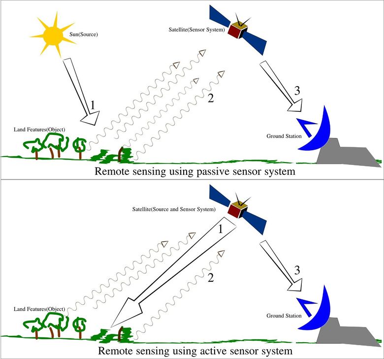
Sensors measure electromagnetic reflectance (how much light reflects off a surface) to collect data about objects. These sensors can be divided into either passive or active sensors. The type of sensor used depends on the desired data to be collected.
Passive sensors measure existing light levels.[2] A normal digital camera recording visible light would be considered a passive sensor, as would a thermal or infrared cameras. These passive sensors can only operate in environments with measurable levels of light. If light levels are too low, the sensors cannot collect information.
Active sensors send out a signal that illuminates the surface and measure the properties of the returning signal.[2] An example of an active sensor would be Light Detection and Ranging (LiDAR). LiDAR sends out short laser bursts and measures the time it takes for the signal to return.[3] LiDAR is used to measure the distance of a surface from the sensor. Active sensors require more energy than passive sensors because they provide their own signal to measure.[2] The advantage of an active sensor is greater operational flexibility; they can operate in dimmer light conditions.

Platforms
Sensors are attached to various types of platforms.[5] A platform is the structure that carries the sensor itself. Platforms can be stationary or designed to move to allow the sensor to collect more data. Platforms are divided into three categories:
- Ground-based - Ground-based sensors are mounted on a platform that stays in contact with the ground.
- Airborne - Airborne sensors are generally mounted on planes or, in some cases, on balloons
- Spaceborne - Spaceborne sensors are mounted on satellites.
Applications in Energy
Remote sensing has a variety of information collection applications in the energy industry. Active sensors can be used for wind resource measurement or to create models of local elevation.[3][6] Wind measurements can be used to locate potential sites for offshore wind turbines[6] Elevation models are useful for planning hydroelectric plants or areas that have fewer obstructions for wind turbines or electricity transmission lines.[6][7][8]
Passive, spaceborne instruments provide images of the surface that are used to identify areas where crude oil or natural gas may be present.[5]BP (2013). "The science of searching". [Online] Available: http://www.bp.com/en/global/corporate/about-bp/what-we-do/finding-oil-and-gas/the-science-of-searching.html</ref> They can also be used to identify areas with the least cloud cover; these areas are better-suited for solar panels.[9]
For Further Reading
- Satellite
- Solar power
- Wind power
- Hydropower
- Energy
- Or explore a random page
References
- ↑ Natural Resources Canada (2011). "Remote Sensing". [Online] Available: http://www.nrcan.gc.ca/earth-sciences/geography-boundary/remote-sensing/11691
- ↑ 2.0 2.1 2.2 P.R. Baumann (2010). "Introduction to Remote Sensing". [Online] Available: http://www.oneonta.edu/faculty/baumanpr/geosat2/RS-Introduction/RS-Introduction.html
- ↑ 3.0 3.1 NOAA (2013). "LiDAR - Light Detection and Ranging - is a remote sensing methods used to examine the surface of the Earth" [Online] Available: http://oceanservice.noaa.gov/facts/lidar.html
- ↑ Wikimedia Commons. (October 4, 2015). Remote Sensing [Online]. Available: https://upload.wikimedia.org/wikipedia/commons/6/61/Remote_Sensing_Illustration.jpg
- ↑ 5.0 5.1 NASA, "What are passive and active sensors?", (Sept.22, 2018) Available from: https://www.nasa.gov/directorates/heo/scan/communications/outreach/funfacts/txt_passive_active.html.
- ↑ 6.0 6.1 6.2 I. Karagali, M. Badger, A.N. Hahmann, A. Pena, C.B. Hasager and A.M. Sempreviva, "Spatial and temporal variability of winds in the Northern European seas," Renew Energy, vol. 57, pp. 200-210, Sept. 2013
- ↑ Z. Xu, F. Yang, Y. Huang, Z. Wang, Y. Liu (2008) "LiDAR applications in the electric power industry" [Online] Available: http://www.isprs.org/proceedings/XXXVII/congress/4_pdf/26.pdf
- ↑ Merrett Survey Partnership (2009). "Hydro Electricity - Mini hydro Schemes" [Online] Available: http://www.lidar.co.uk/Hydro-Electricity.htm
- ↑ Green Power Labs (n.d.) "Resource Assessment". [Online] Available: http://www.greenpowerlabs.com/services_ra.html

