
North Atlantic Oscillation: Difference between revisions
No edit summary |
energy>VDuffy No edit summary |
||
| Line 1: | Line 1: | ||
[[Category:Done | [[Category:Done 2026-07-01]] | ||
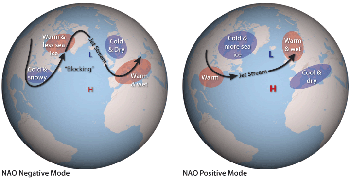
<onlyinclude>'''North Atlantic Oscillation''' (NAO) is a [[climate]] pattern that has a strong influence over North America, Greenland, and Europe.<ref name="RE1">"Climate Variability: North Atlantic Oscillation | NOAA Climate.gov", Climate.gov, 2016. [Online]. Available: https://www.climate.gov/news-features/understanding-climate/climate-variability-north-atlantic-oscillation. [Accessed: 18- May- 2016].</ref> The NAO is a [[Modes of climate variability|natural form of climate variability]], explaining short and long phases in climate caused by natural, large scale features. The NAO forms a permanent low [[pressure]] system which exists over Greenland and Iceland, with an ongoing high-pressure system existing over a group of islands roughly 1400 [[meter|km]] west of Portugal, known as the Azores.<ref name="RE3">”Searching for Atlantic Rhythms? : Feature Articles", NASA, 2016. [Online]. Available: http://earthobservatory.nasa.gov/Features/NAO/. [Accessed: 19- May- 2016].</ref></onlyinclude> Other natural patterns of climate variability include the [[Northern Annular Mode]], [[Pacific Decadal Oscillation]], and the [[Atlantic Multidecadal Oscillation]].[[File:NAO_Schematic_0.png|thumb|600x600px|Figure 1. This image illustrates the surface pressure in both negative and positive modes of the North Atlantic Oscillation.<ref>National Oceanic and Atmospheric Administration. (July 22, 2016). ‘’NAO Modes’’ [Online]. Available: https://www.climate.gov/sites/default/files/NAO_Schematic_0.png</ref>|center]]For most of the year, the high and the low are mild, and their influence on the Atlantic basin climate is minimal. However, when winter enters, all of this begins to change. Both pressure systems grow much more intense and begin to fluctuate from week to week between the two different states. In one state, the '''positive NAO''', the high-pressure system grows especially high. While the second state, the '''negative NAO''', a low-pressure system grows especially low, creating a large pressure difference between the Azores and Iceland.<ref name="RE3" /> See Figure 1 above for a visual representation. | |||
<onlyinclude>'''North Atlantic Oscillation''' (NAO) is a [[climate]] pattern that has a strong influence over North America, Greenland, and Europe.<ref name="RE1">"Climate Variability: North Atlantic Oscillation | NOAA Climate.gov", Climate.gov, 2016. [Online]. Available: https://www.climate.gov/news-features/understanding-climate/climate-variability-north-atlantic-oscillation. [Accessed: 18- May- 2016].</ref> The NAO is a [[Modes of climate variability|natural form of climate variability]], explaining short and long phases in climate caused by natural, large scale features | |||
The influence of the NAO and its phases can be felt across the entire Atlantic Ocean and the surrounding continents. Between the two | The influence of the NAO and its phases can be felt across the entire Atlantic Ocean and the surrounding continents. Between the two clockwise and counterclockwise circulation patterns created by the high and low systems, there is an area where they come together. They form a steady, forward moving current that channels [[weather]] systems from the United States to Europe.<ref name="RE3" /> To understand the NAO, first understanding what air pressure means is important: | ||
[[Air pressure]] is a measure of how much air is pushing down on the surface of the [[Earth]] at any given point.<ref name=RE3/> Normally, high and low pressure systems form when air mass and [[temperature]] differences between the surface | '''[[Air pressure]]''' is a measure of how much air is pushing down on the surface of the [[Earth]] at any given point.<ref name="RE3" /> Normally, high and low pressure systems form when air mass and [[temperature]] differences between the Earth's surface and the upper [[atmosphere]] produce vertical winds (more technically known as vertical currents). In a ''low pressure system'', these vertical winds travel upwards and pull air away from the surface of the [[Earth]], decreasing the air pressure above the ground or sea.<ref name="RE3" /> In contrast, in a [[high-pressure system|''high-pressure system'']], air is being pushed down. The higher in pressure a high-pressure system gets or the lower in pressure a low pressure system gets, the more intense and larger the spinning circulation pattern becomes.<ref name="RE3" /> | ||
Researchers have had relative success with short term forecasts by linking the NAO to [[sea surface temperature]]s through statistical correlation, and over a longer time frame, they have discovered that [[global warming]] may be slowly influencing the strength of the NAO and its effect on the [[climate]].<ref name=RE3/> | Researchers have had relative success with short term forecasts by linking the NAO to [[sea surface temperature]]s through statistical correlation, and over a longer time frame, they have discovered that [[global warming]] may be slowly influencing the strength of the NAO and its effect on the [[climate]].<ref name=RE3/> | ||
==Phases of NAO== | ==The Phases of NAO== | ||
===Positive NAO=== | ===Positive NAO=== | ||
[[File:NAO Positive.png|thumb|350px|right|Figure | [[File:NAO Positive.png|thumb|350px|right|Figure 2. This image illustrates the surface pressure in the positive mode of the North Atlantic Oscillation.<ref>National Oceanic and Atmospheric Administration. (July 22, 2016). ‘’NAO Modes’’ [Online]. Available: https://www.climate.gov/sites/default/files/NAO_Schematic_0.png</ref>]] | ||
:The NAO is considered to be in a positive phase when both the sub polar low and the subtropical high are stronger than average. During positive NAO phases, the increased difference in pressure between the two regions results in a stronger Atlantic [[jet stream]] and a northward shift of the [[storm track]]. Consequently, northern Europe experiences increased [[storm]]iness and [[precipitation]], and warmer than average temperatures that are associated with the air masses that arrive from lower latitudes. At the same time, southern Europe experiences decreased storminess and below average precipitation. In eastern North America, the positive phase of the NAO generally brings higher air pressures.<ref name=RE3/> This causes less snowfall for the Washington DC/New York corridor.<ref name=RE3/> | :The NAO is considered to be in a '''positive phase''' when both the ''sub polar low'' and the ''subtropical high'' are '''''stronger''' than average''. During positive NAO phases, the increased difference in pressure between the two regions results in a stronger Atlantic [[jet stream]] and a northward shift of the [[storm track]]. | ||
:Consequently, northern Europe experiences increased [[storm]]iness and [[precipitation]], and warmer than average temperatures that are associated with the air masses that arrive from lower latitudes. At the same time, southern Europe experiences decreased storminess and below average precipitation. In eastern North America, the positive phase of the NAO generally brings higher air pressures.<ref name="RE3" /> This causes less snowfall for the Washington DC/New York corridor.<ref name="RE3" /> | |||
:See Figure 2 for a visual representation. | |||
[[File:NAO Negative.png|thumb|350px|right|Figure 3. This image illustrates the surface pressure in the negative mode of the North Atlantic Oscillation.<ref>National Oceanic and Atmospheric Administration. (July 22, 2016). ‘’NAO Modes’’ [Online]. Available: https://www.climate.gov/sites/default/files/NAO_Schematic_0.png</ref>]] | |||
===Negative NAO=== | ===Negative NAO=== | ||
:The NAO is in a '''negative phase''' when both the ''sub polar low'' and the ''subtropical high'' are '''''weaker''' than average''. | |||
:The NAO is in a negative phase when both the sub polar low and the subtropical high are weaker than average. During negative NAO phases, the Atlantic jet stream has a more west to east orientation, and this brings decreased storminess, below average precipitation, and lower than average temperatures to northern Europe. In contrast, Southern Europe experiences increased storminess, above average precipitation, and warmer than average temperatures. In eastern North America, the negative phase of NAO generally brings lower air pressure, which leads to winter storms, and cold weather, which are normally meant for Boston and Maine, to start heading south.<ref name=RE3/> | :During negative NAO phases, the Atlantic jet stream has a more west to east orientation, and this brings decreased storminess, below average precipitation, and lower than average temperatures to northern Europe. In contrast, Southern Europe experiences increased storminess, above average precipitation, and warmer than average temperatures. In eastern North America, the negative phase of NAO generally brings lower air pressure, which leads to winter storms, and cold weather, which are normally meant for Boston and Maine, to start heading south.<ref name="RE3" /> | ||
:See Figure 3 for a visual representation. | |||
== For Further Reading == | |||
* [[Modes of climate variability]] | |||
* [[Northern Annular Mode]] | |||
* [[Pacific Decadal Oscillation]] | |||
* [[Atlantic Multidecadal Oscillation]] | |||
* Or explore a [[Special:Random|random page]] | |||
==References== | ==References== | ||
{{reflist}} | {{reflist}} | ||
[[Category: Uploaded]] | [[Category: Uploaded]] | ||
Revision as of 21:54, 30 June 2026
North Atlantic Oscillation (NAO) is a climate pattern that has a strong influence over North America, Greenland, and Europe.[1] The NAO is a natural form of climate variability, explaining short and long phases in climate caused by natural, large scale features. The NAO forms a permanent low pressure system which exists over Greenland and Iceland, with an ongoing high-pressure system existing over a group of islands roughly 1400 km west of Portugal, known as the Azores.[2] Other natural patterns of climate variability include the Northern Annular Mode, Pacific Decadal Oscillation, and the Atlantic Multidecadal Oscillation.

For most of the year, the high and the low are mild, and their influence on the Atlantic basin climate is minimal. However, when winter enters, all of this begins to change. Both pressure systems grow much more intense and begin to fluctuate from week to week between the two different states. In one state, the positive NAO, the high-pressure system grows especially high. While the second state, the negative NAO, a low-pressure system grows especially low, creating a large pressure difference between the Azores and Iceland.[2] See Figure 1 above for a visual representation.
The influence of the NAO and its phases can be felt across the entire Atlantic Ocean and the surrounding continents. Between the two clockwise and counterclockwise circulation patterns created by the high and low systems, there is an area where they come together. They form a steady, forward moving current that channels weather systems from the United States to Europe.[2] To understand the NAO, first understanding what air pressure means is important:
Air pressure is a measure of how much air is pushing down on the surface of the Earth at any given point.[2] Normally, high and low pressure systems form when air mass and temperature differences between the Earth's surface and the upper atmosphere produce vertical winds (more technically known as vertical currents). In a low pressure system, these vertical winds travel upwards and pull air away from the surface of the Earth, decreasing the air pressure above the ground or sea.[2] In contrast, in a high-pressure system, air is being pushed down. The higher in pressure a high-pressure system gets or the lower in pressure a low pressure system gets, the more intense and larger the spinning circulation pattern becomes.[2]
Researchers have had relative success with short term forecasts by linking the NAO to sea surface temperatures through statistical correlation, and over a longer time frame, they have discovered that global warming may be slowly influencing the strength of the NAO and its effect on the climate.[2]
The Phases of NAO
Positive NAO

- The NAO is considered to be in a positive phase when both the sub polar low and the subtropical high are stronger than average. During positive NAO phases, the increased difference in pressure between the two regions results in a stronger Atlantic jet stream and a northward shift of the storm track.
- Consequently, northern Europe experiences increased storminess and precipitation, and warmer than average temperatures that are associated with the air masses that arrive from lower latitudes. At the same time, southern Europe experiences decreased storminess and below average precipitation. In eastern North America, the positive phase of the NAO generally brings higher air pressures.[2] This causes less snowfall for the Washington DC/New York corridor.[2]
- See Figure 2 for a visual representation.

Negative NAO
- The NAO is in a negative phase when both the sub polar low and the subtropical high are weaker than average.
- During negative NAO phases, the Atlantic jet stream has a more west to east orientation, and this brings decreased storminess, below average precipitation, and lower than average temperatures to northern Europe. In contrast, Southern Europe experiences increased storminess, above average precipitation, and warmer than average temperatures. In eastern North America, the negative phase of NAO generally brings lower air pressure, which leads to winter storms, and cold weather, which are normally meant for Boston and Maine, to start heading south.[2]
- See Figure 3 for a visual representation.
For Further Reading
- Modes of climate variability
- Northern Annular Mode
- Pacific Decadal Oscillation
- Atlantic Multidecadal Oscillation
- Or explore a random page
References
- ↑ "Climate Variability: North Atlantic Oscillation | NOAA Climate.gov", Climate.gov, 2016. [Online]. Available: https://www.climate.gov/news-features/understanding-climate/climate-variability-north-atlantic-oscillation. [Accessed: 18- May- 2016].
- ↑ 2.00 2.01 2.02 2.03 2.04 2.05 2.06 2.07 2.08 2.09 ”Searching for Atlantic Rhythms? : Feature Articles", NASA, 2016. [Online]. Available: http://earthobservatory.nasa.gov/Features/NAO/. [Accessed: 19- May- 2016].
- ↑ National Oceanic and Atmospheric Administration. (July 22, 2016). ‘’NAO Modes’’ [Online]. Available: https://www.climate.gov/sites/default/files/NAO_Schematic_0.png
- ↑ National Oceanic and Atmospheric Administration. (July 22, 2016). ‘’NAO Modes’’ [Online]. Available: https://www.climate.gov/sites/default/files/NAO_Schematic_0.png
- ↑ National Oceanic and Atmospheric Administration. (July 22, 2016). ‘’NAO Modes’’ [Online]. Available: https://www.climate.gov/sites/default/files/NAO_Schematic_0.png