Groundwater as a part of the hydrologic cycle: Difference between revisions
m (1 revision imported) |
m (1 revision imported) |
||
| (One intermediate revision by one other user not shown) | |||
| Line 1: | Line 1: | ||
[[Category:Done | [[Category:Done 2021-01-31]] | ||
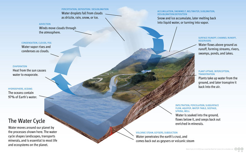
[[ | <onlyinclude>'''Groundwater plays a key role in the [[hydrologic cycle]]'''. The hydrologic cycle is a sequence of [[water]] transformations that occur in the circulation from the atmosphere onto the surface and into the subsurface regions of the [[earth]], and then back from the surface to the [[atmosphere]] once again.<ref name=RE3>"Groundwater", Imnh.isu.edu, 2016. [Online]. Available: http://imnh.isu.edu/digitalatlas/hydr/concepts/gwater/aquifer.htm. [Accessed: 07- Jun- 2016].</ref></onlyinclude> As surface water deposits, such as [[snow]] melt and [[precipitation]], recharge the [[groundwater]], it slowly drains gradually towards a discharge point. | ||
< | [[File:Diagram_of_the_Water_Cycle.jpg|thumb|800 px|center|Figure 1. The water cycle depicting how groundwater is replenished.<ref>wikicommons. (June 26, 2016). ‘’Water Cycle’’ [Online]. Available: https://upload.wikimedia.org/wikipedia/commons/b/b1/Diagram_of_the_Water_Cycle.jpg</ref> Click on the image to see a larger version.]] | ||
When [[precipitation]] falls on a land surface, part of the water runs off into the [[lake]]s and rivers. Some of the water from melted snow and [[rainfall]] seep into the [[soil]] and moves down into the saturated zone.<ref name=RE3/> This process is called recharge and places where recharge occurs are referred to as recharge areas.<ref name=RE3/> Groundwater does not stay below the surface forever and will flow towards the direction of lowest [[hydraulic head]] before eventually resurfacing above ground. This process is called '''groundwater discharge'''. Most groundwater will return to the surface of the Earth in areas of groundwater discharge such as wetlands, lakes, springs, and rivers.<ref name=RE3/> | |||
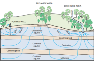
[[File:USGS GW diagram.png|thumb|right|Figure 2. Groundwater flow paths and residence times. Longer flowpaths result in longer residence times.<ref>USGS (June 17, 2020). ''The Hydrologic Cycle and Interactions of Ground Water and Surface Water'' [Online]. Accessible: https://pubs.usgs.gov/circ/circ1139/pdf/part1a.pdf</ref>]] | |||
The [[Water Storage|residence time]] for groundwater can vary from days to tens of thousands of years depending on the characteristics of the reservoir.<ref name=RE3/> Compared to groundwater, the average residence time for river water is about two weeks.<ref name=RE3/> Groundwater discharge can contribute significantly to surface water flow, where in drier periods the flow of some streams may be supplied completely by groundwater (a phenomenon known as [[baseflow]]). The volume of water moving from the saturated zone into streams is determined by the rate of discharge, and these discharge rates can vary along the length of a river or stream.<ref name=BF>USGS (June 18, 2020). ''Recharge Area, Base-flow, and Quick-flow Discharge Rates and Ages, and General Water Quality of Big Spring in Carter County Missouri, 2000-04'' [Online]. Accessible: https://pubs.usgs.gov/sir/2007/5049/pdf/SIR2007-5049.pdf</ref><ref name=RE3/> | |||
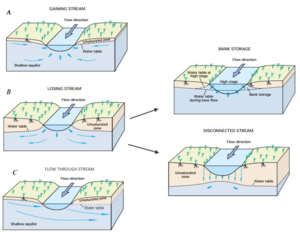
[[File:SurfacewaterGroundwaterInteraction.png|thumb|right|Figure 3. Surface water and Groundwater interactions. Adapted from Winter et al (1998)<ref>Glenn Hall (2017). ''Investigating Aquifer-Stream Connectivity at Steele Park, Langley BC''. [Online] Accessible: https://www.researchgate.net/publication/328492473_Investigating_Aquifer-Stream_Connectivity_at_Steele_Park_Langley_BC</ref>.]] | |||
===Groundwater as a source of energy=== | ===Groundwater as a source of energy=== | ||
Groundwater can be used as a source of [[heat]].<ref name=RE3/> Heat pumps from a ground source are receiving attention as [[energy]] efficient commercial and residential heating and cooling systems. Though the initial costs are higher than air source energy systems, | Groundwater can be used as a source of [[heat]].<ref name=RE3/> Heat pumps from a ground source are receiving attention as [[energy]] efficient commercial and residential heating and cooling systems. Though the initial costs are higher than air source energy systems, due to the additional costs of underground installations, the increased energy efficiency of ground source systems makes them more attractive. <ref name=RE3/> Research into the use of geothermal water has been carried out in a number of institutions across Canada. The City of Moose Jaw has developed a [[geothermal heating]] system for a public swimming pool and recreational facility.<ref name=RE3/> | ||
In Ottawa, Carleton University uses groundwater to heat and cool its buildings.<ref name=RE3/> Since 1995, Sussex, New Brunswick, The Health Centre complex has been utilizing an aquifer for thermal energy storage.<ref name=RE3/> | In Ottawa, Carleton University uses groundwater to heat and cool its buildings.<ref name=RE3/> Since 1995, Sussex, New Brunswick, The Health Centre complex has been utilizing an aquifer for thermal energy storage.<ref name=RE3/> | ||
Estimating the total volume of groundwater on Earth is difficult. There have been estimates that have claimed the quantity of groundwater in the earth could cover the entire surface of the Earth to a depth of 120 metres.<ref name=RE3/> By contrast, the volume of surface water in lakes, [[river]]s, reservoirs, and swamps could be contained in a depth of about one fourth of a metre. Recent research has revealed estimations range from 7,000,000 to 330,000,000 cubic [[meter|kilometre]]s of total groundwater volume.<ref name=RE3/> However, all the estimates imply if we do not include water frozen in [[ice cap]]s, [[glacier]]s and permanent snow; groundwater makes up almost the entire volume of the earth's usable [[fresh water]].<ref name=RE3/> | Estimating the total volume of groundwater on Earth is difficult. There have been estimates that have claimed the quantity of groundwater in the earth could cover the entire surface of the Earth to a depth of 120 metres.<ref name=RE3/> By contrast, the volume of surface water in lakes, [[river]]s, reservoirs, and swamps could be contained in a depth of about one fourth of a metre. Recent research has revealed estimations range from 7,000,000 to 330,000,000 cubic [[meter|kilometre]]s of total groundwater volume.<ref name=RE3/> However, all the estimates imply if we do not include water frozen in [[ice cap]]s, [[glacier]]s and permanent snow; groundwater makes up almost the entire volume of the earth's usable [[fresh water]].<ref name=RE3/> | ||
== For Further Reading == | |||
For further information please see the related pages below: | |||
* [[Hydropower]] | |||
* [[Hydroelectricity]] | |||
* [[Hydrologic cycle]] | |||
* [[Environmental impacts of hydropower]] | |||
* [[Dam failures]] | |||
==References== | ==References== | ||
{{reflist}} | {{reflist}} | ||
[[Category: | [[Category: Uploaded]] | ||
Latest revision as of 19:13, 15 October 2021
Groundwater plays a key role in the hydrologic cycle. The hydrologic cycle is a sequence of water transformations that occur in the circulation from the atmosphere onto the surface and into the subsurface regions of the earth, and then back from the surface to the atmosphere once again.[1] As surface water deposits, such as snow melt and precipitation, recharge the groundwater, it slowly drains gradually towards a discharge point.

When precipitation falls on a land surface, part of the water runs off into the lakes and rivers. Some of the water from melted snow and rainfall seep into the soil and moves down into the saturated zone.[1] This process is called recharge and places where recharge occurs are referred to as recharge areas.[1] Groundwater does not stay below the surface forever and will flow towards the direction of lowest hydraulic head before eventually resurfacing above ground. This process is called groundwater discharge. Most groundwater will return to the surface of the Earth in areas of groundwater discharge such as wetlands, lakes, springs, and rivers.[1]

The residence time for groundwater can vary from days to tens of thousands of years depending on the characteristics of the reservoir.[1] Compared to groundwater, the average residence time for river water is about two weeks.[1] Groundwater discharge can contribute significantly to surface water flow, where in drier periods the flow of some streams may be supplied completely by groundwater (a phenomenon known as baseflow). The volume of water moving from the saturated zone into streams is determined by the rate of discharge, and these discharge rates can vary along the length of a river or stream.[4][1]

Groundwater as a source of energy
Groundwater can be used as a source of heat.[1] Heat pumps from a ground source are receiving attention as energy efficient commercial and residential heating and cooling systems. Though the initial costs are higher than air source energy systems, due to the additional costs of underground installations, the increased energy efficiency of ground source systems makes them more attractive. [1] Research into the use of geothermal water has been carried out in a number of institutions across Canada. The City of Moose Jaw has developed a geothermal heating system for a public swimming pool and recreational facility.[1] In Ottawa, Carleton University uses groundwater to heat and cool its buildings.[1] Since 1995, Sussex, New Brunswick, The Health Centre complex has been utilizing an aquifer for thermal energy storage.[1]
Estimating the total volume of groundwater on Earth is difficult. There have been estimates that have claimed the quantity of groundwater in the earth could cover the entire surface of the Earth to a depth of 120 metres.[1] By contrast, the volume of surface water in lakes, rivers, reservoirs, and swamps could be contained in a depth of about one fourth of a metre. Recent research has revealed estimations range from 7,000,000 to 330,000,000 cubic kilometres of total groundwater volume.[1] However, all the estimates imply if we do not include water frozen in ice caps, glaciers and permanent snow; groundwater makes up almost the entire volume of the earth's usable fresh water.[1]
For Further Reading
For further information please see the related pages below:
References
- ↑ 1.00 1.01 1.02 1.03 1.04 1.05 1.06 1.07 1.08 1.09 1.10 1.11 1.12 1.13 1.14 "Groundwater", Imnh.isu.edu, 2016. [Online]. Available: http://imnh.isu.edu/digitalatlas/hydr/concepts/gwater/aquifer.htm. [Accessed: 07- Jun- 2016].
- ↑ wikicommons. (June 26, 2016). ‘’Water Cycle’’ [Online]. Available: https://upload.wikimedia.org/wikipedia/commons/b/b1/Diagram_of_the_Water_Cycle.jpg
- ↑ USGS (June 17, 2020). The Hydrologic Cycle and Interactions of Ground Water and Surface Water [Online]. Accessible: https://pubs.usgs.gov/circ/circ1139/pdf/part1a.pdf
- ↑ USGS (June 18, 2020). Recharge Area, Base-flow, and Quick-flow Discharge Rates and Ages, and General Water Quality of Big Spring in Carter County Missouri, 2000-04 [Online]. Accessible: https://pubs.usgs.gov/sir/2007/5049/pdf/SIR2007-5049.pdf
- ↑ Glenn Hall (2017). Investigating Aquifer-Stream Connectivity at Steele Park, Langley BC. [Online] Accessible: https://www.researchgate.net/publication/328492473_Investigating_Aquifer-Stream_Connectivity_at_Steele_Park_Langley_BC

